|
|||
|
|
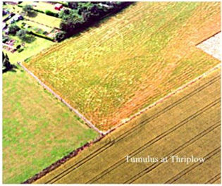
Part
of the darker circle of the tumulus can
be seen clearly at the edge of a field of ripening wheat. The circle
continues as a brighter green in the adjacent pasture.
The tumulus had been excavated in 1953/4 by David Trump who revisited the site with the group in Summer 2000 using dowsing rods to locate the position. Field walking also revealed some pieces of worked flint. |
||
|
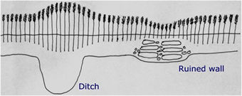
Aerial photography reveals crop marks caused by a variety of processes.....variations in geology, agricultural practices, archaeological features. Observation of these features is made possible by the shallow soil in this area and the low rainfall. During dry periods buried remains have an effect on the crops growing above them, in particular on cereal crops. The diagram on the right shows in simplified form the effects of an old ditch and wall underlying a crop of wheat. Where there has been a levelled ditch the soil is richer and more moist and the crop will ripen more quickly....as in the picture above. Conversely, where there is underlying stone work the soil will be thinner and drier and will delay ripening. Drought years show these effects even more.
|
The size and colour of the leaves and the height of the stem are all affected by the underlying features. |
||
| We also studied photographs at the Cambridge University Aerial Photography Department where there is a collection covering the whole country. These showed further evidence of activity around Thriplow including a possible Iron Age/Roman site in the west of the parish, a Roman villa in the east and several systems of small fields. | |||
|
|
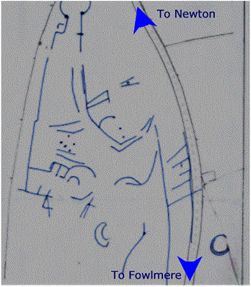
This drawing is based on a photograph from the Cambridge University Collection of Aerial Photographs. It seems to provide evidence of Iron Age agriculture and domestic enclosures, with a later ladder like extension along the line of the present road. |
||
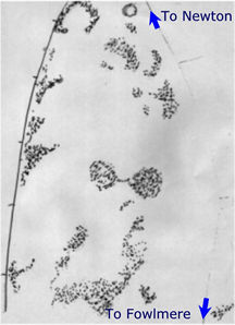 |
Man
made features need to be interpreted alongside geological features.
Here these darker areas show the effects of the periglacial deposits that
produced pingos. Marshy depressions were formed, surrounded by ramparts.
There is some correlation between the man made and natural features. Buildings would have avoided the wet areas and the ponds formed in the depressions may well have been useful water sources for early settlers. |
||
| Links to more details.... | |||
| Documentary evidence | Plane table surveying | ||
| Place name analysis | Resistivity surveying | ||
| Aerial photography analysis | Dowsing and pond dipping | ||
| Geology | Courses and visits | ||
| Soil sampling | Community links | ||
| Metal detecting | Acknowledgements | ||